How to Play the Borderline Game
One country name. One unlabelled world map. One tap. Everything after that is arithmetic — the distance you missed by, converted into a score out of 1000. This page is the complete rule set: the two modes, exactly how the score is computed, which countries are on the map, the controls, and the mistakes that cost the most points.
The rules in five lines
- A country name appears at the bottom of the map.
- The map shows borders but no names — you have to place it from memory.
- Tap where you think the country is. Anywhere inside it is a direct hit.
- The map zooms to the truth, draws your miss, and shows the distance in kilometres.
- Five rounds make a game; the five scores add up to a maximum of 5000.
There is no timer and no second attempt inside a round. Panning and zooming are free — you are not penalised for looking closely, only for being in the wrong place.
The two modes
| Mode | Rounds | Repeatable | Streak |
|---|---|---|---|
| Daily challenge | 5 countries, the same five for everyone that UTC day | Once per day | Counts toward your streak |
| Practice | 5 random countries out of 176 | Unlimited | Does not affect your streak |
The daily is the one that produces a comparable number: same five countries, same map, same day, one attempt. Practice exists so you can go back and fix something specific without burning a daily to do it.
Exactly how the score is calculated
Each round produces a distance in kilometres, and the distance becomes points like this:
score = 1000 × e−km / 800
The distance is a great-circle measurement from your tap to the nearest point of the country's boundary — not to a centre point, and not to a capital. Inside the country the distance is zero and you get the full 1000.
| Distance | Points | Reading it |
|---|---|---|
| 0–50 km | 1000–939 | You know the country, you missed the pixel |
| 50–200 km | 939–779 | Solid; probably a border you have never seen close up |
| 200–700 km | 779–417 | The right neighbourhood, the wrong spot |
| 700–1500 km | 417–153 | The right region, a systematically wrong offset |
| 1500 km+ | < 153 | Wrong region. The mental map has a hole. |
Two rounds with the same score can mean completely different things, which is why the reveal screen always shows the kilometres and not just the points. 700 points from 300 km and 700 points from an unlucky border tap are the same number but not the same problem.
Why the distance goes to the border, not to the centre
Because centres lie. The geometric centre of France sits in the Bay of Biscay; the centre of Norway sits in the Norwegian Sea; forty-odd of the 176 countries in this dataset have a centre that falls outside their own territory. Scoring to a centre point would mark a tap inside France as a miss, which is indefensible.
Measuring to the boundary means the rule is simple and always true: if you are inside the country, you scored 1000. It also makes the score fair for shapes — a long thin country like Chile is no harder to hit than a compact one of similar area.
The 176 countries on the map
The map is Natural Earth 1:110m, which is the coarsest scale that still renders a full world map legibly. It contains 176 countries and does not include the eight smallest states: Monaco, San Marino, Liechtenstein, Andorra, Vatican City, Singapore, Bahrain and Malta.
That omission is deliberate rather than lazy. At world zoom those eight occupy less than a pixel, so any tap would be a lottery rather than a test of memory — and a lottery round is worse than no round, because it teaches you nothing and still costs points.
The difficulty ranking on the home page covers 169 of the 176. Seven entries — Palestine, Northern Cyprus, Kosovo, Western Sahara, Somaliland, the Falkland Islands and the French Southern Territories — are playable but left out of the ranking, because ordering disputed or partially recognised territories by "how hard to find" invites an argument the game does not need to have.
Controls on desktop and phone
| Action | Desktop | Phone |
|---|---|---|
| Move the map | Drag | Drag with one finger |
| Zoom | Scroll wheel | Pinch |
| Answer | Click | Tap |
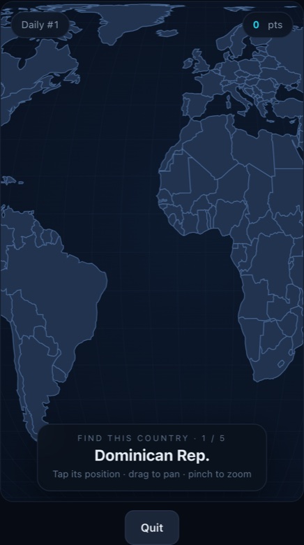
In portrait the map is taller than it is wide, so it is laid out to fill the screen height and you pan sideways to reach the edges of the world. That is intentional: fitting the whole 2:1 map into a phone width would leave it about 190 px tall, which is not enough to place anything.
The mistakes that cost the most points
Answering too early
The most expensive habit is tapping as soon as the name appears. Two seconds of panning to find a coastline can turn a 1,200 km answer into an 80 km one — the difference between 223 and 905 points, on every round.
Neighbour confusion
Dense regions produce the big misses: the Balkans, Central America, West Africa and the Gulf. If you can name only one country in a cluster, you do not know where the others are either. The fix is to learn the cluster as a group, not one country at a time.
Similar names
Guinea, Guinea-Bissau, Equatorial Guinea and Papua New Guinea are four different places on two different continents. Same for Niger and Nigeria, Austria and Australia, Slovakia and Slovenia. These pairs account for a surprising share of very large errors.
Forgetting the antimeridian
Fiji, Samoa, Tonga, Kiribati and New Zealand sit at the far left and right edges of a flat world map, which is the opposite of where they sit on a globe. If you are confident you tapped Fiji and lost 3,000 points, this is usually why.
How to practise on purpose
Track kilometres, not points. Points compress at the top of the curve, so a run that looks like a plateau in score can still be a steady improvement from 600 km average error to 350 km.
Play one region at a time even though practice deals randomly. It feels less varied and it works far better, because reinforcement needs repetition of the same neighbours.
Write down the countries that cost you more than 1,000 km. That list is short, it is stable, and it is the only thing worth deliberately memorising. Everything else you will pick up by playing.
Frequently asked questions
Do I need an account to play the Borderline game?
No. There is no sign-up, no login and no profile: the streak, daily result and best total are written to your browser's local storage, so they survive a refresh but not clearing site data or switching device. The one thing that does leave your browser is a finished daily — the date, your score and a random device ID generated on your own device — which is what lets us show what share of today's players you beat.
What happens if I tap the wrong country?
You get scored by distance like any other tap — there is no penalty flag and no second chance in that round. If the tap lands inside a different country, the reveal screen tells you which one you hit, because that is usually the useful part of the feedback.
Why is the daily different on someone else's phone?
It should not be. The five countries are derived from the UTC date, so they are identical everywhere; only the countdown to reset looks different if you are in another time zone. If two players see different countries on the same UTC day, that is a bug worth reporting.
Can I pause in the middle of a daily?
No. A tap is an answer, and progress is only written when the five rounds are finished — so closing the tab mid-run means starting that day's daily again from round one. Nothing is recorded for an unfinished run.
Does the Borderline game work offline?
Not reliably. There is no service worker, so offline play depends entirely on whether your browser still has the page and the map data in its cache. The game is designed to be loaded once and played on a connection.
Play the Borderline game
Five countries a day, the same five for everyone, scored in kilometres. No account, no install, no labels to lean on.